GET /map.{svg,png}
The GET endpoint turns query parameters into a static SVG or PNG map. Because the entire request is a URL, you can drop it straight into an <img> tag, a Markdown image, or an email. The response is permanently cached, so repeat loads are essentially free.
:::tip When to use GET vs POST
Use GET when you have up to roughly 40 regions and your data fits comfortably in a URL (~2 KB). For larger datasets, structured JSON bodies, or CSV uploads, use POST /render/map instead.
:::
Live example
https://api.maproll.io/map.png?scope=world&data=US:200,CN:150,IN:80,BR:60,RU:120,DE:95,FR:40,GB:55,JP:90&theme=dark&legendTitle=Sample
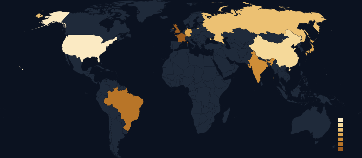
Query parameters
| Param | Type | Default | Allowed values | Notes |
|---|---|---|---|---|
scope | string | required | world, RO, … | See Scopes. |
data | string | — | id:value[:#hex] pairs, comma-separated | Choropleth mode. See Data syntax below. |
regions | string | — | id,id,… comma-separated | Highlight-only mode (no values). Cannot be combined with data. |
theme | string | dark | dark light light-blue light-mono dark-blue dark-mono | See Themes. |
format | string | derived from extension | svg png | Normally set by the URL path (.svg / .png). |
width | integer | 1200 | 1–8000 | Output width in pixels. |
height | integer | auto | 1–8000 | Output height in pixels. Omit to let the projection determine the aspect ratio. |
projection | string | per-scope | naturalEarth1 albersUsa conicConformal mercator equalEarth | See Projections. |
colorScale | string | sequential | sequential diverging categorical | See Color scales. |
classification | string | quantile | quantile jenks equal custom | Binning method for sequential scales. Defaults to quantile. See Classification. |
breaks | string | — | Comma-separated numbers, 1–20 values | Custom bin edges when classification=custom. |
legend | boolean | true | true false 1 0 | Show or hide the legend. |
legendTitle | string | — | Max 64 chars | Label shown above the legend. |
legendLayout | string | vertical | vertical horizontal continuous | See Legend. |
title | string | — | Max 120 chars | Map title shown at the top. See Title & subtitle. |
subtitle | string | — | Max 160 chars | Smaller text below the title. |
attribution | boolean | true | true false 1 0 | Shows "© OpenStreetMap contributors". Disable only if your embed context has its own attribution. |
logo | boolean | false | true false 1 0 | Shows the maproll wordmark. See Attribution & logo. |
northArrow | boolean | false | true false 1 0 | Renders a north arrow. See Overlays. |
scaleBar | boolean | false | true false 1 0 | Renders a scale bar. |
graticule | boolean | false | true false 1 0 | Renders latitude/longitude grid lines. |
markers | string | — | See format below | Point markers with optional icon, label, and position. See Markers. |
patterns | string | — | id:pattern,… | Per-region fill patterns. See Patterns. |
annotations | string | — | id:text,… | Per-region tooltip text. See Annotations. |
routes | string | — | See format below | Great-circle arcs between pairs of points or ISO codes. See Routes. |
labels | string | — | ISO or id,id,… | Region labels on the map. ISO labels all polygons. See Region labels. |
labelMinArea | number | — | 0–1000000 | Minimum polygon area (SVG units²) below which labels are suppressed. |
proportional | string | — | Same id:value[:#hex] syntax as data | Sized circles at region centroids. See Proportional symbols. |
proportionalMax | number | — | 0–200 | Maximum circle radius in pixels. |
proportionalMin | number | — | 0–100 | Minimum circle radius in pixels. |
Data syntax
The data parameter encodes choropleth values as a comma-separated list of pairs:
data=id:value
data=id:value:#rrggbb
id— canonical region identifier (ISO 3166-1 alpha-2 for countries, ISO 3166-2 for sub-national regions).value— numeric value. May be negative or decimal.#rrggbb— optional 6-digit hex color that overrides the scale-derived fill for this region. See Color overrides.
Examples:
# Three countries, sequential ramp
data=US:200,CN:150,DE:95

# With per-region color override
data=US:200,CN:150,DE:95:%23ff0000

# Romanian counties
data=RO-B:500,RO-CJ:200,RO-IS:150
The # character must be URL-encoded as %23 in query strings.
The markers parameter uses semicolons to separate markers (because each marker already uses colons internally):
markers=lat,lon[:icon][:label][:labelPosition]
The routes parameter also uses semicolons:
routes=from>to[:#rrggbb][:width][:solid|dashed][:arrow]
Where from and to are either ISO codes (e.g. US) or lat,lon literals (e.g. 44.43,26.10).
Response
See Response headers & caching.
Related
- POST /render/map — for large datasets and structured payloads
- Response headers & caching
- Errors
- Scopes
- Themes