Markers
Markers overlay point symbols on top of any map — choropleth, highlight-only, or blank land. Pick from 30 built-in icons, add an optional label, and control label placement and size via the URL. Color and rotation require the JSON body (POST /render/map).
Icon gallery
All 30 icons at default size, placed in a grid across the world map:
https://api.maproll.io/map.png?scope=world&theme=light&width=1500&markers=70,-150:dot:dot:bottom%3B70,-90:square:square:bottom%3B70,-30:triangle:triangle:bottom%3B70,30:cross:cross:bottom%3B70,90:star:star:bottom%3B70,150:pin:pin:bottom%3B40,-150:flag:flag:bottom%3B40,-90:airport:airport:bottom%3B40,-30:anchor:anchor:bottom%3B40,30:car:car:bottom%3B40,90:bicycle:bicycle:bottom%3B40,150:helicopter:helicopter:bottom%3B10,-150:ship:ship:bottom%3B10,-90:train:train:bottom%3B10,-30:truck:truck:bottom%3B10,30:house:house:bottom%3B10,90:building:building:bottom%3B10,150:factory:factory:bottom%3B-20,-150:hospital:hospital:bottom%3B-20,-90:tank:tank:bottom%3B-20,-30:base:base:bottom%3B-20,30:bomb:bomb:bottom%3B-20,90:fist:fist:bottom%3B-20,150:soccer-ball:soccer-ball:bottom%3B-50,-150:megaphone:megaphone:bottom%3B-50,-90:mountain:mountain:bottom%3B-50,-30:fire:fire:bottom%3B-50,30:lightning:lightning:bottom%3B-50,90:warning:warning:bottom%3B-50,150:person:person:bottom

Icon library
| Group | Icons |
|---|---|
| Generic shapes | dot, square, triangle, cross, star |
| Location | pin, flag |
| Transport | airport, anchor, car, bicycle, helicopter, ship, train, truck |
| Buildings | house, building, factory, hospital |
| Military / conflict | tank, base, bomb |
| Civic / activity | fist, soccer-ball, megaphone |
| Nature / hazard | mountain, fire, lightning, warning |
| Social | person |
Examples
Five markers with different icons and label positions:
https://api.maproll.io/map.svg?scope=world&theme=dark&markers=44.43,26.10:pin:Bucharest%3B52.52,13.40:airport:Berlin%3B38.90,-77.04:flag:Washington:left%3B-33.87,151.21:anchor:Sydney:bottom%3B35.68,139.69:star:Tokyo:top

Markers over a choropleth — icons draw on top of the fill layer:
https://api.maproll.io/map.svg?scope=world&data=DE:100,RO:80,US:200,AU:50,JP:90&theme=light&markers=44.43,26.10:pin:Bucharest%3B52.52,13.40:airport:Berlin

Parameters
| Param | Type | Default | Allowed | Notes |
|---|---|---|---|---|
markers | string | — | See URL syntax below | Semicolon-separated list of marker definitions |
icon | string | dot | Any of the 30 icon names | URL-encoded as part of the marker token |
label | string | — | Up to 64 chars | Optional text drawn next to the icon. The 64-char cap is enforced on the JSON body; the URL parser does not truncate |
labelPosition | string | right | top, bottom, left, right | Which side of the icon the label appears on |
size | number | 17 | 1–200 (px) | Fifth field of the URL marker token, or size in the JSON body |
color | string | theme text color | 6-digit hex #rrggbb | JSON body only — not available in the URL |
rotation | number | 0 | -360–360 (degrees) | JSON body only — not available in the URL |
URL syntax
markers=lat,lon[:icon][:label][:labelPosition][:size];lat,lon[:icon][:label][:labelPosition][:size];...
Field order within a token: lat,lon, then optionally icon, then label, then labelPosition, then size. Omit any trailing field you don't need.
# Minimal: just a dot at a coordinate
markers=44.43,26.10

# Icon + label
markers=44.43,26.10:pin:Bucharest

# Icon + label + position
markers=44.43,26.10:pin:Bucharest:top

# Icon + label + position + size (5th field, 1–200 px)
markers=44.43,26.10:pin:Bucharest:right:28

# Multiple markers (semicolon-separated; encode ; as %3B in a URL)
markers=44.43,26.10:pin:Bucharest%3B52.52,13.40:airport:Berlin
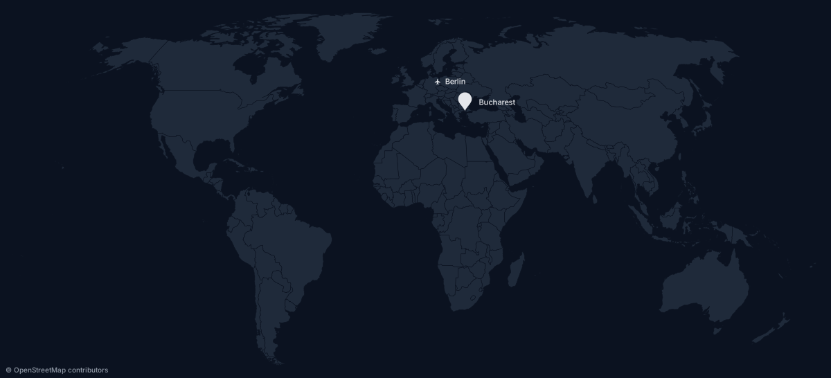
Two markers at different sizes — 28 px and 10 px:
https://api.maproll.io/map.svg?scope=world&theme=dark&markers=44.43,26.10:pin:Bucharest:right:28%3B52.52,13.40:airport:Berlin:right:10
JSON body syntax
Use POST /render/map with markers: MarkerInput[] for per-marker color and rotation:
{
  "scope": "world",
  "theme": "dark",
  "markers": [
    { "lat": 44.43, "lon": 26.10, "icon": "pin", "label": "Bucharest", "color": "#ff0000", "size": 20 },
    { "lat": 52.52, "lon": 13.40, "icon": "airport", "label": "Berlin", "color": "#00ff00", "rotation": 45 }
  ]
}
Notes
colorandrotationare JSON-only.sizeis available in both forms; per-marker color and rotation require thePOSTendpoint.- Off-screen markers are silently skipped. Points outside the projection's visible domain (e.g. clipped by the projection boundary) produce no output rather than an error.
- Limit: 1000 markers per render. Exceeding it returns
400 too_many_markerson the URL path, and a schema error (Array must contain at most 1000 element(s)) onPOST. The separateinvalid_markerscode covers malformed marker syntax in the URL, not the count cap. - Detailed icons at small sizes. Icons like
car,helicopter,bicycle, andhospitallose distinguishing features below ~10 px. Preferdot,square,triangle,star, orpinfor dense sets where each marker is small. - Anchor, bicycle, and fist render as stroke (outline), not fill. All other icons are fill-based.
soccer-ball,hospital, andwarningusefill-rule="evenodd"so inner subpaths cut holes (the medical cross, the warning!).- Each marker has a native
<title>tooltip. Hovering in a browser shows the label text (or coordinates if no label).
Related
- Routes — draw great-circle paths between points; pairs naturally with endpoint markers
- Annotations — add hover tooltip text to regions (not markers)
GET /map.{svg,png}— full query parameter reference- POST /render/map — JSON body schema for per-marker color and rotation